by Hazel Anna Rogers for the Carl Kruse Blog
Ah, the map. That flimsy scroll which guides us through lands near and far, that which cuts the landscape into jigsaw pieces, that which sheds some light unto the unknown. It is certainly a strange thing to consider a map as representative of a space, for – surely – the ‘perfect’ map cannot exist, for it would cover the land it has thereby mapped, so would be useless. But we take maps as scripture, using them to define our world through subjective boundaries in space.
Partiality in maps, that is to say inclusion or exclusion of certain aspects of the land from them, is inescapable. Maps are inevitably metaphorical in that they always demand some sort of cartographic generalization*. This abstracts them from the concrete nature of the space they are depicting. Someone traces their finger up a line on a map, a line no more than a few millimeters wide, a line colored with a weak pallid green. Somehow, she knows that line is the path she walks upon, a path littered with flora and beast and forest. In this way, maps are fertile ground for the imagination; they force their readers to create a palpable visual representation from a mere few lines encircling a blank canvas.
An author can control the way a reader considers a space by choosing to provide and omit certain aspects of the map they present to them. A map details possibility, limitation, and aspiration with but minor strokes of a pen. Maps can be more descriptive than narratives in that they can encompass a space and give meaning to the space in such a condensed, yet recognizable, manner.
Phillip and Juliana Muehrcke suggest that ‘[t]he essence of maps…[is] controlled abstraction’ and further that ‘the abstract nature of maps stimulates fantasy and imagination, leads to frustration, fosters speculation, aids (and sometimes hinders) decision making, [and] facilitates understanding’ when they are used in literature. One might more readily associate the use of maps with fantasy fiction, but Anne Frank’s maps of her house plan in Amsterdam, especially her depiction of the infamous ‘Annex’, serve to render her sense of entrapment ever more palpable when included beside her journal entries.
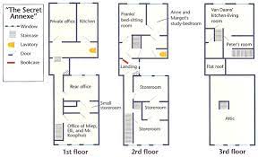
Diagram of the secret annex – Anne Frank House
Many other authors have used maps as a means to guide the reader’s perception of a landscape in the context of a fictional narrative, such as Herman Melville, James Joyce, J.R.R. Tolkien, and Daniel Defoe. The implication of a map representing the orchestrated ‘selection’ and ‘distortion’ of a landscape by an author suggests the importance of controlled abstraction in forming a narrative that uses cartography as an important element of its storytelling. How could we envision the unfathomable journey of Frodo and Sam to Mordor if we hadn’t the map of Middle Earth given to us by Tolkien (and his son), which details the mountainous plains and oneiric areas of terror the two hobbits must encounter on their quest?
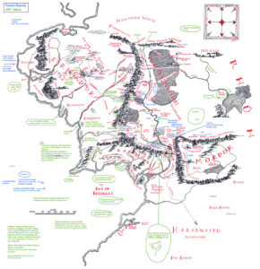
Map of Middle Earth showing Mordor to the east by Tolkien. Image courtesy of the Tolkien Society.
If only to better comprehend the sheer breadth of a journey, a map is integral, even more so if the land explored is fictional. But a map itself, it could be argued, is inherently fictional. There is no verity in its blank expanse, that which supposedly represents the world we see around us, a world that is infinitely changeable and diverse. Yet we believe the map and we trust it sincerely enough that we refer to it time and time again to guide our sense of space and to learn new things about the world we live on. In this way, a map is the perfect device for a novelist; it brings veracity to a text like nothing else could. We can travel vicariously using a map without moving from the very seat we are sat upon; the globe is there before us, and one can journey from South America to Russia within a second of moving one’s finger to the right.
Referring to Max Byrd’s article ‘This is not a map’, Katharine Harmon and Peter Turchi suggest that ‘literary artists […] have used maps to persuade their readers of the ‘reality’ of fiction’ and further that ‘every map is a selection (and, necessarily, distortion) of information meant to convey a particular understanding of a place.’ We are thus forced into submission by a fictional map; we observe its boundaries, whether they be of water or land, and we live by them as the characters in a story must do also. We are manipulated by a map, and in some ways, despite them enabling our imagination of a space, they also entrap us and force us to conceive of a space in the way that the author does.
Harmon and Turchi assert that maps are infinitely flexible, in that ‘[t]hey are about exploration, orientation, and dislocation; politically imposed boundaries; and other notions of persuasion and projection[.]’ This flexibility can be seen in a comparison of cartographical works throughout the ages: some depict islands we now know to not exist, and all have boundaries that shift as easily as dust when a man, or government, or monarch decides that they must. How is it possible that one can break the expanse of Africa into so many separate parts, and that these splits be deemed so politically charged that they have the capacity to invoke war between the people of either side? It seems almost ridiculous to consider a map in this arbitrary way, and to reflect on the fact that these politically-inflicted boundaries have caused some of the bloodiest conflicts in history.
I myself adore maps. They remind me of trips to France, when my mother would hold a worn road map and attempt to guide my father through the landscape (though sometimes unsuccessfully). Maps have become intrinsic to our understanding of travel, providing us with the knowledge to journey with nothing more than a sheet of paper in tow. While the world has converted almost instantaneously to the glorious Satnav, that which tells us where to go with a robotic, uncharismatic voice, we can find some solace in the simple map, and marvel at the fact that, without it, we might not know that Italy is in the shape of a boot, or that Japan looks like a seahorse, or that London is almost level with the Netherlands, or that Norway is right beside Scotland. Without a map, we might not understand the world at all.
(*referring to the changes made in a map when one derives a small scale map from a large scale map, or vice versa. This is also relevant in the data provided on the map itself.)
(Harmon, Katharine, and Peter Turchi. “MAPS IN FICTION.” The Wilson Quarterly (1976-), vol. 33, no. 4, 2009, pp. 11–11. JSTOR, www.jstor.org/stable/20700621. Accessed 22 Apr. 2021.)
=============
Homepage for the Carl Kruse “Rummaging for the Useful.”
Contact: carl AT carlkruse DOT com
Other articles by Hazel Anna Rogers include Paper Books, E-Book Dreams and Those Glorious Trees.
Find Carl Kruse on Goodreads here.
Yaaaaaas! A fellow map lover!
Love this article! Also a map lover
I love maps too!